

| Common Residential Scale | 1 inch = 10 feet (1:120) |
| Plant Circle Size Represents | Mature spread, not installed size |
| North Arrow Purpose | Orients sun exposure for each area of the yard |
| Title Block Location | Typically in the lower-right corner of the drawing sheet |
| Plant Schedule Also Called | Plant list or planting legend |
| Graphic Scale Bar Advantage | Remains accurate even if the plan is photocopied at a different size |
What a Landscape Plan Actually Shows
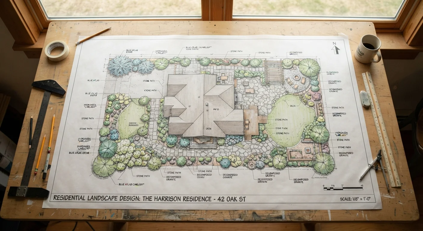
When a landscape designer or contractor hands you a set of drawings, it can look like abstract art at first glance. In reality, a landscape plan is a bird's-eye view of your property drawn to a precise, proportional scale. It maps out where plants, hardscape elements (patios, paths, walls), drainage features, and utility lines will be placed relative to your home and property boundaries.
Understanding how to read one puts you in a much stronger position - you can check that the design matches your expectations, catch potential issues before installation begins, and ask sharper questions during contractor walkthroughs. For a deeper look at how outdoor components work together visually, see our guide on hardscape vs. softscape planning.
| Common Residential Scale | 1 inch = 10 feet (1:120) |
| Plant Circle Size Represents | Mature spread, not installed size |
| North Arrow Purpose | Orients sun exposure for each area of the yard |
| Title Block Location | Typically in the lower-right corner of the drawing sheet |
| Plant Schedule Also Called | Plant list or planting legend |
| Graphic Scale Bar Advantage | Remains accurate even if the plan is photocopied at a different size |
Understanding Scale and the Scale Bar
Scale is the foundation of any plan. A common residential landscape scale is 1 inch = 10 feet, meaning every inch on the paper represents 10 real-world feet. You'll typically see this written as a ratio (1:120) or spelled out in a title block - a bordered box, usually in a corner, that lists the project name, designer, date, and drawing scale.
Most plans also include a graphic scale bar - a ruled line segment divided into labeled intervals. This bar remains accurate even if the plan is printed at a different size, which is why experienced contractors use it rather than trusting a written ratio on a photocopy.
Practical tip: Use a simple ruler against the scale bar to measure distances directly on the plan. If a patio is shown as 1.5 inches wide and the scale is 1 inch = 10 feet, that patio is 15 feet wide in real life.
Scale
The proportional relationship between distances on a drawing and real-world measurements. For example, a scale of 1 inch = 10 feet means every inch on the plan equals 10 feet on the ground.
Title Block
A bordered area on a drawing - usually in a corner - listing the project name, designer, revision date, and drawing scale. Always check it first when reading a new plan.
Plant Schedule
A table on or accompanying a landscape plan that lists each plant symbol or code alongside the botanical name, common name, installed size, and quantity required.
Leader
A thin line with an arrow that connects a label or code on a plan to the element it identifies, keeping drawings legible without crowding text onto the drawing itself.
Mature Spread
The expected width of a plant at full growth. Plant circles on a landscape plan are typically sized to represent mature spread, not the plant's size at the time of installation.
Keynote
A numbered or lettered callout on a drawing that refers the reader to a separate legend or specification sheet for detailed construction or material information.
Decoding Plant Symbols and Hardscape Notation
Plants on a landscape plan are almost always represented as circles or organic blob shapes viewed from above. The size of the circle typically reflects the plant's mature spread - not its size at installation. A large circle doesn't mean a large plant goes in today; it means the designer has accounted for future growth.
- Deciduous trees - often shown as irregular, branching circles with a trunk dot at center
- Evergreen trees - typically rendered as star-burst or triangular shapes
- Shrubs - smaller rounded forms, sometimes grouped with a boundary line around a mass planting
- Ground cover or perennials - hatched or dotted patterns filled within a planting bed boundary
- Lawn areas - usually left white or lightly stippled (dotted) on the plan
Hardscape elements like patios, paths, and retaining walls are drawn as solid outlines with a material fill pattern - crosshatching for concrete, brick running-bond patterns for pavers, and so on. Dimensions are noted with arrows and numeric callouts in feet and inches.
If you're planning a deck as part of your landscape, note that deck structures follow similar notation conventions; our article on deck building covers structural and permit considerations alongside design.
Reading Plant Lists, Leaders, and Other Notation
Every landscape plan should include a plant schedule (also called a plant list or legend). This table cross-references each symbol or code on the plan to a botanical name, common name, size at installation, and quantity. When you see a circle labeled QV (5), the plant schedule tells you that's five Quercus virginiana (live oaks), each installed as a 3-inch-caliper specimen.
Leaders are thin lines with arrows connecting a label or code to the element it identifies. They keep the drawing uncluttered without losing specificity. Keynotes are numbered callouts tied to a separate keynote legend explaining construction details - for example, a circled 3 might reference a specific edging detail or irrigation specification in the project documents.
A north arrow appears on virtually every plan. Orient yourself using it so you understand which parts of the yard face south (typically the sunniest), which face north (shadier), and how seasonal sun angles will affect plant selection and outdoor living zones. This sun orientation context connects directly to outdoor entertaining layout principles.
Permits and Plan Accuracy
Some landscape improvements - including retaining walls above a certain height, irrigation connections, and structures - may require permits in your municipality. Always verify local requirements with your building department before work begins. A landscape plan submitted for permits may need to meet additional notation standards beyond what a design-only drawing includes.
For a broader view of how landscaping functions as a home improvement - not just decoration - the article on landscaping as a home upgrade covers grading, drainage, and plant selection in practical terms.